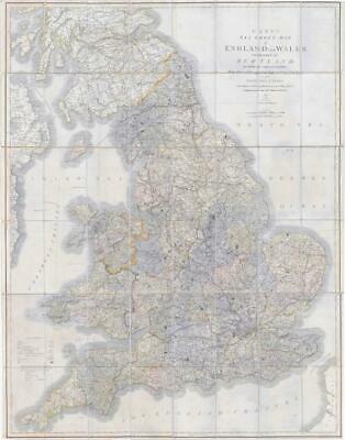
1842 - " CARY'S SIX SHEET MAP of ENGLAND and WALES with part of SCOTLAND on which are carefully laid down. All the Direct and Principal Cross Roads, the Course of the Rivers and NAVIGABLE CANALS, Cities, Market and Borough-Towns with the principal Villages Parks & c COMPILED FROM THE MOST RECENT SURVEYS 1842 - London Published by J CARY No 86 St James;s Str "
An enormous folding map dissected into 48 sections and laid to linen & with original hand colour wash & outline.
Measuring approximately 108cm x 135cm and comes with the original slip case and publisher's label.
The overall condition is very good. There are a number of linen splits on some of the folded corners and the outer edges are showing signs of wear, but generally fine.
£330.00