1786
A huge Three sheet map titled
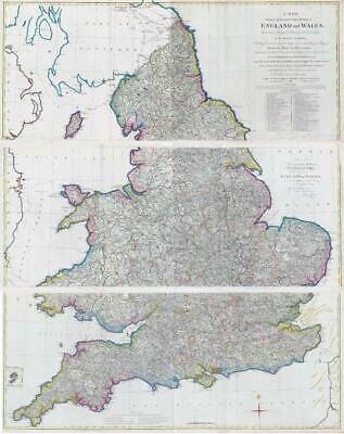
"A NEW Physical, Historical & Political Map of ENGLAND and WALES, From actual Surveys & Astronomical Observations of the ROYAL SOCIETY, Exhibiting the natural state of its Surface, by describing the great Range of Mountains, Hills and High Lands, which seperate the Heads of the Rivers & point out their Course from its Spring to the Ocean; All the Noblemens and Gentlemens seats, Cities, Boroughs, Market-Towns, Rectories, Vicarages, Chapels, Vallies, Rivers, Canals, Bathing Places, Parks, Forests, Marshes, Turnpike & Principal Cross Roads, with the distances from Town to Town according to the Mile Stones & other exact Mensurations. By John Andrews, Geographer and Map-seller, No 211 facing Air Street Piccadilly, 1786"
An outstanding example of this extremely rare three sheet map of England & Wales. Each sheet approx 133cm x 55cm and overall when joined together 133cm x 165cm. Table of the vales and valleys, table of explanation, compass rose and dedication, inset map of the Scilly Isles. Early hand colouring.
£1,045.00