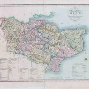
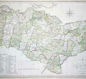
1659 - Very Rare ORIGINAL LARGE Map of KENT by PHILIP SYMONSON Overton
A large original map titledA NEW DESCRIPTION OF KENT Divided into the fyve Lathes. A fine copper engraved map on 2 joined sheets. A very beautiful and detailed map by Philip Symonson. Taken from Thomas Philipott's book on the county entitled 'VILLARE CANTIANUM or KENT SURVEYED AND ILLUSTRATED, the map, which was engraved by Charles Whitwell and first published in 1596, is certainly one of the finest maps of Kent and is thought to be the first large scape map of any county in England.The plate was acquired in the mid 1600s by Peter Stent and was re-engraved to include views of Dover Castle and Rye, by Wenceslaus Hollar along with a change showing Stent as the publisher. Hand coloured with inset views of RYE DOVER CASTLE and ornate strapwork cartouche.This is one of the rarest of all Kent Maps.
Overall in good condition with and measuring approx 580mmx 800cm with early hand colouring and good margins, perfect for mounting and framing. Central fold as issued with the usual very light age toning, for a map of over 350 years old
£850.00