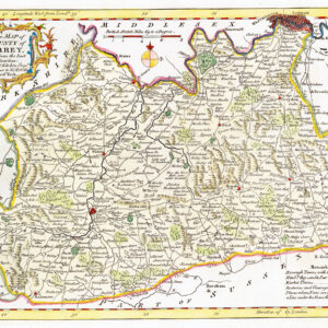
1646 - "SURRIA ver-nacule SURREY"
A striking and highly detailed copper engraved map of Surrey, England.
Map gives several details concerning cites, villages, rivers, mountains, forests. Map adorned with a strapwork title cartouche with cherubs and animals. Map embellished with 5 cherubs, 10 heraldic familiary coat of arms, a large royal armorial and another cartouche including two scales of distance surmonted by cherubs.
Jansson began to prepare his volume devoted to the British Isles c.1640. In 1644 he published eleven county maps in an appendix to the "Atlas", ut they appeared from 1646 in the "Novus Atlas". Jansson's county maps are seen far less frequently than those of his rival Blaeu, but are similar in appearance with coats of arms and decorative title cartouches. Jansson, like Blaeu, used Speed maps when creating his own thus showing hundreds but no roads. However, Jansson (and Blaeu) chose to omit Speed's innovative town plans.
Size approximately 55cm x 47.5cm.
Condition is generally fine with central fold as issued.
On the reverse, there has been some re-enforcement professional repairs at the lower part of the central fold.
£385.00