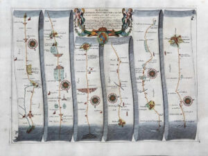
1806 - "Roads to Arundel, Bognor (by Petworth), Chichester and Portsmouth - ROADS MEASURED FROM LONDON BRIDGE"
An original antique map taken from Laurie & Whittle's 'Travellers Companion' showing areas including Newington Turnpike, Putney Heath, Petersham, Thames Ditton, Kingston, Sunbury, Staines, Cobham, Ripley, Woking, Guildford, Godalming, Farnham, Witley, Hindhead, Hambledon, Haslemere, Liphook, Alton, Petworth, Midhurst, Petersfield, Arundel, Chichester, Havant, Portsmouth, Gosport, Fareham etc.
Overall size 263mm x 310mm and ready for mounting and framing.
CONDITION:
Overall excellent condition. These particular Laurie & Whittle Road Maps are difficult to find in better condition. This example with vibrant original outline hand colouring.
£75.00