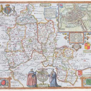
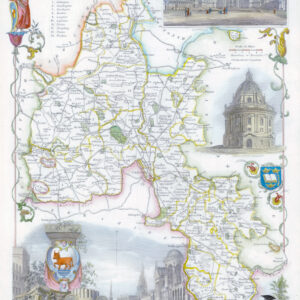
1627 "OXFORDSHIRE Described with ye Citie and the Armes of the Colledges of ye famous University Ao 1605"
A fine, early Sudbury and Humble edition of John Speed's map of Oxfordshire in colour. Towns and cities are highlighted in red, decorative college arms, and the (supposed) years of their foundation are found on either side of the map. A detailed inset map of the city of Oxford is in the upper right corner with a separate key with 28 listed city landmarks. The arms of the earl of Oxford to the right. Two academic university figures are seen standing with a pair of compass dividers either side of a striking globe, representing the scale of miles. A strapwork border design and the royal coat of arms complete this map wonderfully well.
Size approx 52.5cm x 40cm including margins. Condition is good with central fold as issued. The left side margin has been added later and there is overall mild toning. The hand colouring appears to be early.
John Speed (1552-1629) is the most famous of all English cartographers primarily as a result of The Theatre of the Empire of Great Britaine, the first Atlas of the British Isles. The maps from this Atlas are the best known and most sought-after of all county maps. The maps were derived mainly from earlier prototypes fo Christopher Saxon and Robert Norden but with notable improvements include parish "Hundreds" and county boundaries, town plans and embellishments such as the coats of arms of local Earls, Dukes and the Royal Household.
£1,100.00