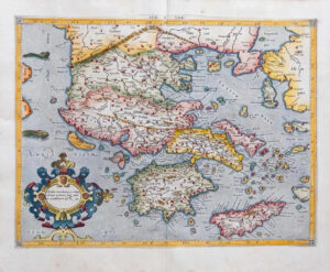
1613 - 'MACEDO NIA EPIRUS ET ACHAIA'
This is a fine and rare 1613 Map of Greece north of the Pelopponesus, engraved in 1595 by Gerard Mercator and included here in a 1613 edition of Jodocus Hondius 'Atlas'.
It shows present day Thrace, Macedonia, Epirus, Thessaly, Euboea and Central Greece, including the island of Corfu and the northern shore of the Peloponnese. Mercator's superb engraving is displayed in the water and mountain areas; the map is further embellished with an attractive strap work cartouche topped by a skull.
Fine condition with early hand colouring and central fold as issued, with Latin text on the reverse.
Overall size approximately 51cm x 40m including the margins.
Gerard Mercator (1512 - 1594) is one of the most famous cartographers of all time. Mercator was born in Flanders and educated at the Catholic University in Leuven. After his graduation in 1532, Mercator worked with Gemma Frisius, a prominent mathematician, and Gaspar a Myrica, a goldsmith and engraver. Together, these men produced globes and scientific instruments, allowing Mercator to hone his skills.
With his wife, Barbara, Mercator had six children: Arnold, Emerentia, Dorothes, Bartholomeus, Rumold, and Catharina. In 1552, Mercator moved to Duisburg from Leuven, where he lived for the rest of his life. In 1564, he was appointed the official cosmographer to the court of Duke Wilhelm of Cleve.
Mercator’s most important contribution was the creation and popularisation of a projection which now bears his name. On Mercator projection maps, all parallels and meridians are drawn at right angles to each other, with the distance between the parallels extending towards the poles. This allowed for accurate latitude and longitude calculation and also allowed navigational routes to be drawn using straight lines, a huge advantage for sailors as this allowed them to plot courses without constant recourse to adjusting compass readings.
£300.00