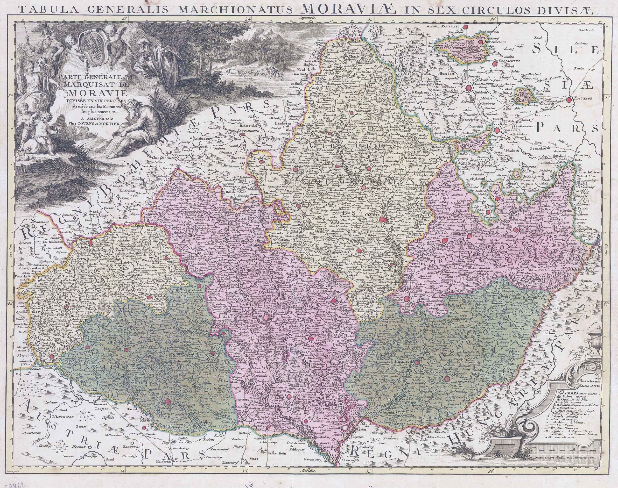
1740 "Carte Generale du Marquisant de Moravie divisee en six Cercles dressee sur les Memories les plus nouveaux. A Amster Chez Covens et Mortier".
A striking and highly detailed large format copper engraved map of Moravia divided into districts, in the Czech Republic. With decorative title cartouche and legend cartouche on upper left and lower right corners. Shows transportation routes and main towns highlightened in red. Engraved by Condet. The map is adorned with a large decorative title cartouche embellished with a Fluvial deity, Athena, Ares, cherubs and a regional amorial. a monument-style topographic key & mileage scale cartouche complete the map.
Covens & Mortier was one of the largest and most successful publishing firms in Dutch history and continued in business for over a century. Pierre Mortier the Elder (1661-1711) had obtained a privilege in 1690 to distribute the works of French geographers in the Netherlands. After his widow continued the business for several years, Cornelis (1699-1783) took over in 1719. In 1721, Mortier forged a partnership with Johannes Covens (1697-1774), who had recently married Cornelis’ sister. They published under the joint name of Covens & Mortier. Johannes continued to work with Cornelis’ heirs after his death. In 1774, upon the death of his father, Johannes Covens II (1722-1794) took over his father’s share. In 1778, the company changed its name to J. Covens & Zoon, or J. Covens & Son. Covens II’s son, Cornelis (1764-1825), later inherited the business and brought Petrus Mortier IV back into the fold. Petrus was the great-grandson of Petrus Mortier I. From 1794, the business was called Mortier, Covens & Zoon, or Mortier, Covens, & Son. The business specialized in publishing French geographers including Deslisle, Jaillot, Janssonius, and Sanson. They also published atlases, for example a 1725 reissue of Frederik de Wit’s Atlas Major and an atlas, with additions, from the works of Guillaume Delisle. There were also Covens & Mortier pocket atlases and town atlases. The company profited from acquiring plates from other geographers as well. For example, the purchased Pieter van der Aa’s plates in 1730. Finally, they also compiled a few maps in house. At their height, they had the largest collection of geographic prints ever assembled in Amsterdam.
Size approx 67cm x 54.3cm including margins. Central fold as issued with original hand colour. condition is excellent.
£550.00