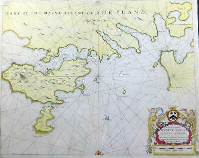
c1723 - Large original copper engraved antique map titled: "PART OF THE MAINE ISLAND OF SHETLAND - To the Rt Honorable DANIEL EARL of Nottingham, this chart is most humbly dedicated and presented by Capt Greenvile Collins, Hydroghe to the King"
An interesting large engraved Sea Chart map showing Shetland and the island of Brassey and the nearby coast lines. Large decorative Cartouche, compass rose and fine early hand colouring.
This map was created by the maritime Cartographer, Captain Greenvile Collins. Collins was an officer of the Royal Navy and prominent hydrographer who was commissioned by King Charles II in 1676 and appointed by Samuel Pepys (then secretary to the Admiralty) to chart the Coasts of Great Britain and the result was his 'GREAT BRITAINS COASTING PILOT'.
Condition: Central fold as issued. This map is in excellent condition with central fold as issued and superb early hand colouring.
Overall size including margins 58cm x 46cm.
£165.00