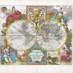
c1810 "MAPPE-MONDE ou CARTE GENERALE de toutes les parties connues de la Surface du Globe selon la projection des Cartes reduites ou se trouvent les Nlles Decouvertes du Capit. Cook Par Delmarche Successeur de M. de Vagondy......".
World Map on Mercator’s projection showing Australia according to Cook with an imaginary southern coast and prior to the discoveries made by Bass and Flinder’s of Bass Strait. The Hawaiian Islands discovered by captain Cook on his third and final voyage of exploration. Highlighted in colour is the distribution of various religious faiths. Gilles Robert de Vaugondy was one of the leading exponents of the French School of Theoretical Cartography like Nicholas Bellin which popularised the notion of an imaginary east coast of Australia. A highly respected Royal cartographer.
Overall size approx 43cm x 31cm. Condition is excellent with central fold as issued. Original/early hand colour.
In 1757, Gilles and Didier Robert De Vaugondy published The Atlas Universel, one of the most important atlases of the 18th century. To produce the atlas, the Vaugondys integrated older sources with more modern surveyed maps. They verified and corrected the latitude and longitude of many regional maps in the atlas with astronomical observations. The older material was revised with the addition of many new place names. In 1760, Didier Robert de Vaugondy was appointed geographer to Louis XV. Gilles and Didier Robert De Vaugondy produced their maps and terrestrial globes working together as father and son. Globes of a variety of sizes were made by gluing copperplate-printed gores on a plaster-finished papier-mache core, a complicated and expensive manufacturing process, employing several specialists. In some cases it is uncertain whether Gilles or Didier made a given map. Gilles often signed maps as "M.Robert", while Didier commonly signed his maps as "Robert de Vaugondy", or added "fils" or "filio" after his name. The Robert de Vaugondys were descended from the Nicolas Sanson family through Sanson's grandson, Pierre Moulard-Sanson. From him, they inherited much of Sanson's cartographic material, which they combined with maps and plates acquired after Hubert Jaillot's death in 1712 to form the basis the Atlas Universel. Sources from the Depot de la Marine, the official French repository for maritime-related information, were used for their maps of Canada and South America.
£220.00