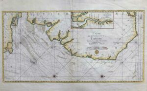
Original copper engraving, hand colored in outline, when published.
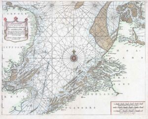
Double page sea chart covering detailed the Cap Verde Islands in the Atlantic Ocean (Isla de San Antonia, San Vincente, S. Lucia, S. Nicolas, I. do Sal, de Bona Vista, do Mayo, S. Jago, del Fuogo, de Brava).
Many place names of smaller towns are listed along the coast lines the islands. As well some anchor places and depths are marked. In the upper center a large figurative title cartouche in full contemporary colours. Below an additional cartouche with a scale of miles is present. In the center of the sea chart a compass rose.
Overall size approx 60cm x 49cm. Condition is generally very fine.
£275.00