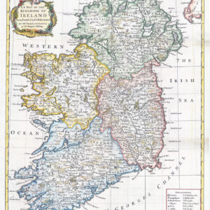
c1689 - Hiberniae Regnum tam in praecipuas Ultoniae, Connaciae, Lageniae, et Momoniae, quam in minores earundem Provincias, et Ditiones subjacentes peraccurate divisum
Decorative antique engraved map of Ireland, hand-colored by regions and published by Nicolaus Visscher. The map shows towns, roads, counties, rivers, lakes, castles, and more. Ireland is visible in its entirety, divided into its four provinces: Ulster in the north, Connacht in the west, Leinster in the east, and Munster in the south. Part of Galloway, the Isle of Man, and Cornwall are all also shown. The map includes two marvelous cartouches.
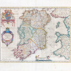
The contrast between the two coats of arms is interesting. The one on the upper left shows the Celtic Harp, a symbol of Ireland, and is framed by passive cherubs. The other coat of arms is in the lower right; this one shows the coat of arms of the United Kingdom and it is framed by a much more regal and powerful scene, including the English lion and the Scottish unicorn. The balance of power is clearly evident; this leaves the impression of looking at a minor constituent kingdom rather than a nation among equals.The map names William III as King of England, who was known as William of Orange before his ascension to the British throne in 1689. Size approx 48 x 57cm. Condition generally fine with tight but clear margins all round. The bottom right on verso has had some re-enforcement restoration.
£700.00