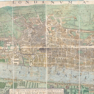
1837 - " MOGG'S NEW PLAN OF LONDON "
Finely engraved, detailed and very scarce plan of London, performed by one of the leading London mapmakers and sellers of the period. The map covers what might now termed central London, bounded by Pentonville in the north, Sloane Square, Lambeth Palace and Newington Butts in the south, and from Paddington and Knightsbridge in the west east to Stepney Church Yard. Below the map is an alphabetical table in twenty-four columns, printed in letterpress, headed 'A List of 900 of the Principal Places with references to their situation on the above plan.', giving a detailed overview of the buildings.
Copper engraving, widest: 457 x 883; widest, with the text: 538 x 891 mm, in original wash and outline colour, dissected and mounted on linen, folding into the original paper slipcase with printed title label: 'Mogg's New Plan of London .' with an engraved view of St. Paul's Cathedral; the slipcase crushed with paper loss to the two spines. Howgego 362(1).
Generally fine condition with very light overall age toning. Some of the edges and joints with wear and a few of the dissected section with very minor loss. There are a few small areas where the linen is torn.
£600.00