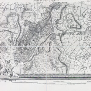
1811 "A SURVEY OF THE ROADS AND FOOTPATHS IN THE PARISH OF ISLINGTON From a Plan in the Vestry Room Drawn in the Year 1735".
A fine original antique map engraved by J Hawksworth & published for 'The History & Antiquities of the Parish of Islington in the County of Middlesex' by John Nelson. This scarce map, published in 1811, shows the Parish of Islington in 1735. The map is oriented towards the North West. The cluster of buildings at the bottom of the map is the (then) village of Islington. The road running from the bottom of the map towards the top left hand corner of the map is St John Street - Upper Street - Holloway Road - Highgate Hill. At the top left of the map, the Hamlet of Highgate is shown, along with Upper Holloway and Lower Holloway in the left upper-centre of the map.
"CRUCH END" (Crouch End) is shown at the top of the map. The two hamlets shown in the lower right hand part of the map are Newington Green & Kingland. The manor of Highbury is shown slightly to the right and below the centre of the map, with Canonbury House, shown to the right of Upper Street. The road running down the left hand side of the map is Dartmouth Park Hill - Brecknock Road - York Way. The current site of Kings Cross station is in the lower left hand corner of the map. Condition is generally good with several folds, as issued. There is an historical repaired tear in the upper left. Size approx 26.5 x 38.5cm.
£330.00