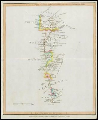
1806 - "Completion of the Roads to the Lakes of Lancaster, Westmoreland & Cumbeerland as far as Hinckley & Leicester - ROADS MEASURED FROM HICK'S HALL"
An original antique map taken from Laurie & Whittle's 'Travellers Companion' showing the areas from Holloway Hill, Barnet, St Albans, Harpenden, Dunstable, Luton, Woborn, Newport Pagnell, Northampton, Wellington, Market Harborough, Lutterworth, Billesdon, Leicester etc.
Overall size 263mm x 310mm and ready for mounting and framing.
CONDITION: Overall excellent condition. These particular Laurie & Whittle Road Maps are really difficult to find in better condition as most of them are damp stained. This example with vibrant original outline hand colouring.
£60.00