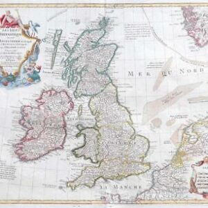
1792 - "LES ISLES BRITANNIQUES Par ROBERT DE VAUGONDY Geog Corrigee par le Con Lamarche Geog Seccesseur de Vaugondy l'An 3me de la Republique Franc".
A fine antique map of the British Isles by Robert de Vaugondy.
Overall size approximately 43cm x 31cm including margins.
Condition is excellent with central fold as issued and original outline hand colour.
Gilles Robert de Vaugondy (1688-1766) and his son, Didier Robert De Vaugondy (1723-1786) based a lot of their maps on the work of the Sanson family to whom they were also related. There seems to have been considerable cross-over in their material, and Gilles' maps were often signed with the name: M.Robert, and son Didier signed his Robert de Vaugondy. Perhaps their greatest achievement was perhaps one of the most striking atlases of the 18th century, The Atlas Universal, a large volume that took around fifteen years to complete. They struck two versions: one a large folio that ran for 601 copies and the other a ¾ folio that ran for 517 copies. Both were published in Paris in 1757 and are now highly collectable. Despite the general sparsity of decoration on the whole within the maps, considerable time and artistry went into the Vaugondy cartouches. They commissioned an number of engravers to depict decoratively the postal routes within Britain and other countries in western Europe. Perhaps the most renowned of these engravers were the Haussard sisters, but all involved in the compilation of these most gratifying creations were undoubtedly some of the most highly skilled of the age.
£77.00