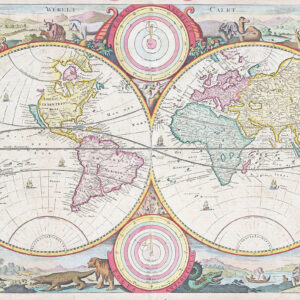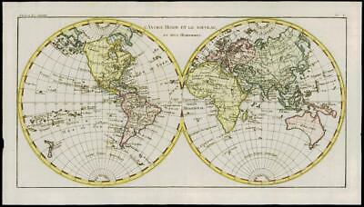
1780 - An original Antique Map by Rigobert Bonne & Guillaume Thomas Raynal titled:' L'ANCIEN MONDE ET LE NOUVEAU EN DEUX HEMISPHERES '
Overall size of map is 44cm x 25cm with large margins, perfect for mounting & framing
CONDITION:
Excellent overall condition with hand colouring and the usual centrefold, as issued. Blank on verso.
A fine example of Rigobert Bonne and G. Raynal's 1780 map of the world on a hemispherical projection. Offers a number of interesting details corresponding to the knowledge of the world at the time. Western North America exhibits a pre-Cook configuration with a curious archipelago that can be understood as a proto-understanding of the Aleutian Islands. On the opposite side of the world Tasmania is joined to the mainland of Australia. Neither Antarctica (which had yet to be discovered) nor the mythical Terre Australis appear in the southern latitudes - a significant advancement in the cartographic perspective of the region. Otherwise this is a fairly accurate picture of the Earth
PROVENANCE
Drawn by R.Bonne for G.Raynal's "ATLAS DE TOUTES LES PARTIES CONNUES DU GLOBE TERRESTRE, DRESSE POUR l'HISTOIRE PHILOSOPHIQUE ET POLITIQUE DES ETABLISSEMENTS ET DU COMMERCE DES EUROPEENS DANS LES DEUX INDES"
CARTOGRAPHERS
Rigobert Bonne (1727-1795 ) was one of the most important cartographers of the late 18th century. In 1773 he succeeded Jacques Bellin as Royal Cartographer to France in the office of the Hydrographer at the Depôt de la Marine. Working in his official capacity Bonne compiled some of the most detailed and accurate maps of the period. Bonne's work represents an important step in the evolution of the cartographic ideology away from the decorative work of the 17th and early 18th century towards a more detail oriented and practical aesthetic. With regard to the rendering of terrain Bonne maps bear many stylistic similarities to those of his predecessor, Bellin. However, Bonne maps generally abandon such common 18th century decorative features such as hand coloring, elaborate decorative cartouches, and compass roses. While mostly focusing on coastal regions, the work of Bonne is highly regarded for its detail, historical importance, and overall aesthetic appeal.
Guillaume Thomas Raynal (April 12, 1711 - March 6, 1796) was a French writer, philosopher, and historian active during the Enlightenment. Raynal was educated as a Jesuit, but left the order for unknown reasons, and moved to Paris where he dedicated himself to the production of a number of minor but popular historical works. Raynal's histories opened doors to elite social and artistic circles where he met and befriended various members of the Philosophe Coteries. Raynal's most important work is generally considered to be a 1770 collaboration with Diderot and others entitled, L'Histoire philosophique et politique des établissements et du commerce des Européens dans les deux Indes. Some of the philosophical ideas developed in the book drew negative attention from the authorities who banned the book and posted a notice for the arrest of its authors. Raynal fled to Berlin and later to St. Petersburg, where he lived for a number of years before returning to France in 1787. Though not a cartographer Raynal's name is often attached to several Atlases by Rigobert Bonne, from whom he composed the text.
£269.50