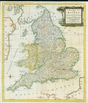
1762 - " An accurate Modern MAP of the RIVERS of ENGLAND and WALES with the Cities, Borough and Market Towns situate thereon or adjacent thereto, from the best Authorities "
A neatly engraved map of England and Wales showing all the rivers, with all the cities, borough and market towns. The elegant title cartouche, most attractively presented with its depiction of columns, tree and foliage, states of the publishers 'Robert Sayer is to be found at the Golden Buck in Fleet Street, and Carington Bowles next to the Chapter House in St. Paul's Church Yard'. Hand coloured.
An attractive and uncommon map, unusual for the period in that it lacks roads, thus allowing for clarity of place names and detail.
CONDITION: Excellent condition with folds as issued. Large margins, perfect for mounting and framing.
SIZE: 43cm x 48cm.
£200.00