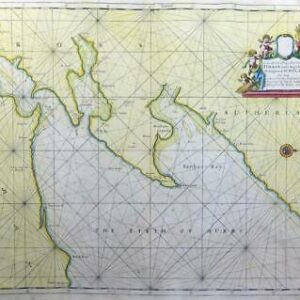
1760 - "A New and Correct Chart of the Harbour of Corke By The Revd J Lindsay".
An antique sea chart of 'Corke' from the "Great Britain's Coasting Pilot" by Captain Greenville Collins who was commissioned by Charles II in 1676 and appointed by Samuel Pepys (who was then Secretary to the Admiralty), to chart the coasts of Great Britain and he produced his 'Great Britain’s Coasting Pilot' in 1693. The last atlas was published in1764. This map was added to the 1760 edition and was engraved by J. Mynde.
Size 576m x 46cm including margins.
Condition generally fine with central fold as issued and later hand colour.
£450.00