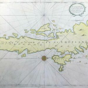
c1760 - 'Carte de L'Entree de la TAMISE avec les bancs, passes, Isles et Costes comprises entre SANDWICH et CLAY'
A magnificent and very large chart of the Thames Estuary and the North Sea coast from Sandwich in Kent up through Essex & Suffolk to Clay in Norfolk. A detailed inset chart of the River Thames as far as London is also included. North is oriented to the right of the page. The map was originally published in the "Neptune Francois" in Paris in 1693 by Alexis Hubert Jaillot and this was soon pirated by Pierre Mortier in Amsterdam and published the same year.
This example is from a later publication of the "Neptune Francois" by J.N.Bellin to whom the original plates passed in an official capacity,AND this exact plate was used by the Depot De LA Marine.The chart is crossed by numerous rhumb lines and includes only coastal detail (no inland towns are named) along with sounding depths and sand bank
Approx 93cm x 58cm including margins with central fold as issued. Perfect for mounting and framing.
Generally excellent condition with some repairs paper splits down the central fold.
£600.00