"L'Europe Dressée Sur les Nouvelles observations faites en toutes les parties de la Terre Rectifiée. Paris: Chez le fils de l'auteur Rue St.Jacques a lenseigne de la Place des Victoires, 1740"
NOLIN, Jean-Baptiste (1657-1725)] and Jean-Baptiste NOLIN II (1686-1762)
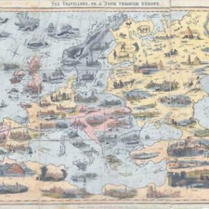
A rare and monumental original antique copperplate wall map of Europe by one of the great masters of French cartography with original outline hand colour measuring approx 130 x 146cm. The map surrounded by 30 vignettes with text fields relating to various events in European history, in addition with a magnificent title cartouche at the upper left side. CONDITION - Four large copper engraved joined sheets with additional sheets with decorative border vignettes added, partly with small spots, small margins and creases, partly small tears along the folds.
Jean-Baptiste Nolin was one of the most successful and certainly the most ambitious French cartographer of his time.
He established a family empire in Paris in the 1680s. In an extraordinary way, he managed to combine top-class decorative ornamentation with the serious goal of creating maps that reflected the most advanced rendering of geographical details. The artistic verve of his compositions testifies to a style that preserves the rhetorical ambitions of the Baroque while anticipating the playful elegance of the Rococo. His masterpieces, many of which, like the present wall map, were monumental in scale, were an expression of Nolin's ambition to overwhelm the competition in a very demanding market. Nolin, who was highly controversial, occasionally referred to himself as "the king's engraver," an appointment of which, curiously, the royal court never learned. In his quest to provide his maps with the latest geographical details, he rarely hesitated to seek information from his eminent contemporaries, especially Guillaume De L'Isle and Vincenzo Maria Coronelli, Jean-Dominique Cassini, and the Sieur de Tillemon. These competitors were sometimes unhappy about Nolin taking over their intellectual property, and De L'Isle successfully sued Nolin for plagiarism in 1705. However, the larger-than-life Nolin always seemed to overcome these challenges and left behind a thriving business that his son carried on. The present map was created by Jean-Baptiste Nolin II in 1740 and is largely based on earlier maps by his father. It is a very detailed and refined image of Europe, which at that time was in the process of increasing its imperialistic influence on the other continents. This map is an artistically virtuoso composition of monumental proportions, as the image is surrounded by thirty vignettes, each framed by individual baroque borders, depicting various events in European history and textual narratives. The greatest decorative flourish of the composition is certainly the title cartouche, located at the upper left of the main image. Finely engraved classical gods and allegorical personifications frame the design. Iconologically, they are meant to endow Europe with the various powers and virtues they represent. For example, Mercury, the messenger god of travel, trade, and theft, is present to protect and speed European ships as they sail the seas on global missions of conquest and trade. This wall map is one of the most important works of the Nolins. It is not only a masterful work of art and a fascinating image that explores the frontiers of European geographical knowledge, but also a living testimony to a dramatic transitional period in the history of cartography and society in general.
£4,000.00