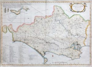
1675 "DORSETSHYRE with the Shyre towne Dorchester described as also the Armes of such noble families as have bene honoured with the Titles there-of since the Normans conquest to this present Anno 1662".
A fine example of John Speed’s county map of Dorset, featuring an inset plan of Dorchester in the upper left corner, and Coats of Arms of local noble families in the lower left. Portland Bill, the most southern point along the coastline, is labelled as Portland Iland. Various sea monsters and ships decorate the Channel.
John Speed (1552-1629) is the most famous of all English cartographers primarily as a result of The Theatre of the Empire of Great Britaine, the first Atlas of the British Isles. The maps from this Atlas are the best known and most sought-after of all county maps. The maps were derived mainly from earlier prototypes fo Christopher Saxon and Robert Norden but with notable improvements include parish "Hundreds" and county boundaries, town plans and embellishments such as the coats of arms of local Earls, Dukes and the Royal Household.
Condition is excellent with central fold as issued. Overall size approx 54.5 42.5cm
£650.00