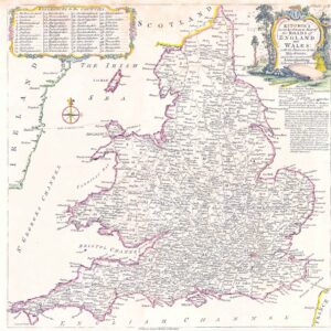
1646 - A large original antique print map titled: " RADNORIA COMITATUS Radnor Shire "
A highly decorative copperplate engraved 17th Century Map England by Joan Blaeu with fine later hand colouring. Spanish text on verso. Excellent condition with central fold as issued.
Fine hand coloured example of a very decorative map.
Approximately 51cmx 61cm with large margins, perfect for mounting and framing.
Jan Blaeu (1596-1673) the son of William Janszoon Blaeu (1571-1638), founder of the Dutch publishing house. The county maps of England and Wales appeared in the fourth volume in 1645 of their world atlas, Theatrum Orbis Terrarum which commenced publication with the first volume in 1630 and eventually expanded to 12 volumes. The maps were closely copied from John Speed and the text verso translated into various languages from William Camden's Britannia. The production of the maps was of the highest quality with consistently fine and uniform engraving embellished with decorative title cartouches and armorial bearings, high quality printing from Blaeu's own printing house using the finest quality rag paper and usually completed with hand colouring carried out within Blaeu's own workshops. The atlases containing the English county maps were published from 1645 until 1667, the maps remained unaltered throughout publication. A fire at Blaeu's printing house destroyed most of the plates in 1672 and Jan Blaeu died the following year effectively ending the Blaeu publishing dynasty.
£160.00