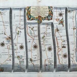
1719 - Original Antique engraving titled: ' The Continuation of the Road from LONDON to HOLYHEAD by Thomas Gardner '
A fine antique Road Strip Map by Thomas Gardner shows the Road from Chester to Holyhead via Hawarden, Northorp, Denbigh, Beaumaris & Anglesea.
The strip map shows the main road and crossroads leading to various towns along the way. The engraving details the surrounding topography including churches, rivers, bridges, pastures, woods, forests and hills. On each strip is a compass rose showing the direction of travel as well as the distance, in miles, from the start point.
Taken from 'A POCKET GUIDE FOR THE ENGLISH TRAVELLER Being a compleat survey and admeasurement of all the principal roads and most considerable cross roads in England and Wales. In one hundred copper plates'.
Excellent condition with later hand colouring. Size 28cm x 19cm.
£45.00