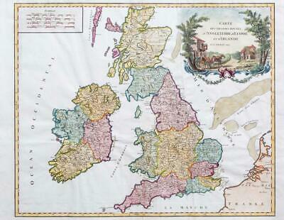
c1790 - A large original engraved map titled: " Carte des Grandes Routes D'Angleterre, D'Ecosse, et D'Irland "
A detailed map of England, Scotland, Ireland and Wales, tracking the primary postal roads. Large decorative cartouche to the top right depicts travellers outside an Inn. Despite being published after the French Revolution of 1789 (hence the removal of Robert's role as Geographer to the King), the map still shows England divided into the Saxon Kingdoms.
Gilles Robert de Vaugondy (1688-1766) was the head of a leading family of geographers in eighteenth century France. Gilles got his start when he jointly inherited the shop of Pierre-Moullart Sanson, grandson of the famous geographer Nicholas Sanson. The inheritance included the business, its stock of plates, and a roller press. In 1760 Gilles became geographer to King Louis XV. His son, Didier Robert de Vaugondy (ca. 1723-1786), was also a geographer and the two worked together. They were known for their exactitude and depth of research. In 1757, they produced the Atlas Universel, considered an authority for many years.
Excellent condition with two folds as issued with later colouring.
Overall size approximately 64cm x 49cm including margins.
£145.00