0 items
Search for:
Prints
Maps
Books
Ephemera
New Acquisitions
News
About Us
Contact
Subscribe
Home
/
Maps
/
English Counties
/
London Maps Plans and Transport
/ 1917 Original antique BOUNDARY COMMISSION MAP OF POPLAR East London
1917 Original antique BOUNDARY COMMISSION MAP OF POPLAR East London
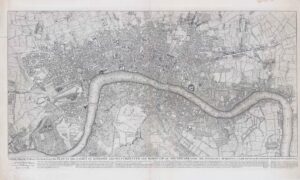
1917 "BOUNDARY COMMISSION, 1917 POPLAR Boundaries"
Original antique map showing the Divisions and Municipal Wards.
Published by the Ordnance Survey Office.
Size approximately 28cm x 44cm including margins.
£
50.00
1 in stock
1917 Original antique BOUNDARY COMMISSION MAP OF POPLAR East London quantity
Add to cart
Related products
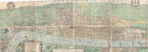
1737 CIVITAS LONDINIUM ANO DNI CIRCITER MDLX Ralph Agas HUGE LONDON PLAN
£
2,400.00
Add to cart
1878 Antique Map Rocque LONDON KENT CHISLEHURST BROMLEY MOTTINGHAM SUNDRIDGE (1)
£
90.00
Add to cart
1878 Antique Map John Rocque LONDON GREENFORD WEMBLEY HARROW NORTHOLT (13)
£
90.00
Add to cart
c1885 BACON'S NEW MAP OF CENTRAL LONDON DIVIDED INTO HALF MILE SQUARES
£
175.00
Add to cart
Related products
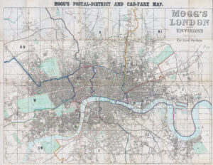
1857 MOGG'S POSTAL DISTRICT AND CAB FARE MAP LONDON ENVIRONS Folding (LM40)
£
290.00
Add to cart
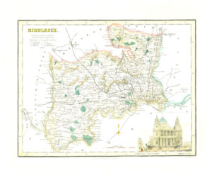
1836 Original Antique map of MIDDLESEX by Fullerton ST PAUL'S CATHEDRAL (SM5-24)
£
45.00
Add to cart
c1885 BACON'S NEW MAP OF CENTRAL LONDON DIVIDED INTO HALF MILE SQUARES
£
175.00
Add to cart
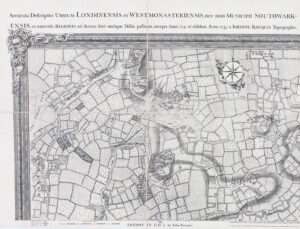
1763 THIS PLAN OF THE CITIES OF LONDON WITH THE CONTIGUOUS BUILDING Rocque
£
3,150.00
Add to cart
Search for:
About Us
Shop
contact us
Shipping & Returns
Privacy Policy
© Copyright 2024 - The Antique Paper Company - All Rights Reserved
heart
shopping-cart
linkedin
facebook
pinterest
youtube
rss
twitter
instagram
facebook-blank
rss-blank
linkedin-blank
pinterest
youtube
twitter
instagram