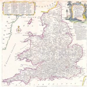
1817 "Langleys New Travelling and Commercial Map of England and Wales containing a list of all the Cities, Boroughs and Market Towns the days on which the markets are held together with the rates of postages and measured miles from London. Printed and published by Langley and Belch 173 High Street Borough London January 1st 1817".
Folding map dissected into 16 sections and laid on linen. Map with original hand colouring by county, with mail coach and turnpike roads marked. Cartouche of a rural glade to upper right. Uncoloured engraved panorama view of London from across the river, to the upper edge. Three uncoloured engraved panels showing Vauxhall, Waterloo and Southwark Bridges, to lower edge. Side panels with colour coded titles of towns/cities detailing distances from London, market days and rates of postage.
Overall size approx 67 x 47cm. Overall condition is generally good. There are some occasional tone spots and on verso, the folds of the linen back have been re-enforced with archival support tape.
£400.00