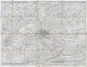
1920s "BACON'S NEW MAP OF THE ENVIRONS OF LONDON - SCALE 1 INCH TO A MILE".
A fine original antique large scale map encompassing the home counties all round London. Stretching, in the north, from AMERSHAM across to CHIGWELL and in the south from WORPLESDON across to SEVENOAKS. Excellent details showing the Railway Stations and Routes, along with the Main Roads.
Condition is generally good to fine and map folding into titled Cover Binding. Overall size once opened up approx 100cm x 74cm.
£130.00